BIMSAR
Optimized building and infrastructure monitoring using artificial intelligence
With the “BIMSAR” project, experts at the Research Center of Post-Mining aim to improve the monitoring of buildings and infrastructure in areas subject to ground movements, which can be caused by mining. To this end, Building Information Modeling (BIM) methods are being used and combined with radar satellite remote sensing data from the Copernicus program (Sentinel-1) and local data sets and knowledge, and evaluated comprehensively for the first time.
Artificial intelligence methods are used to merge and evaluate the large amount of information. This innovative combination of novel AI methods and model-based data analysis methods is gradually creating a holistic, hybrid model.
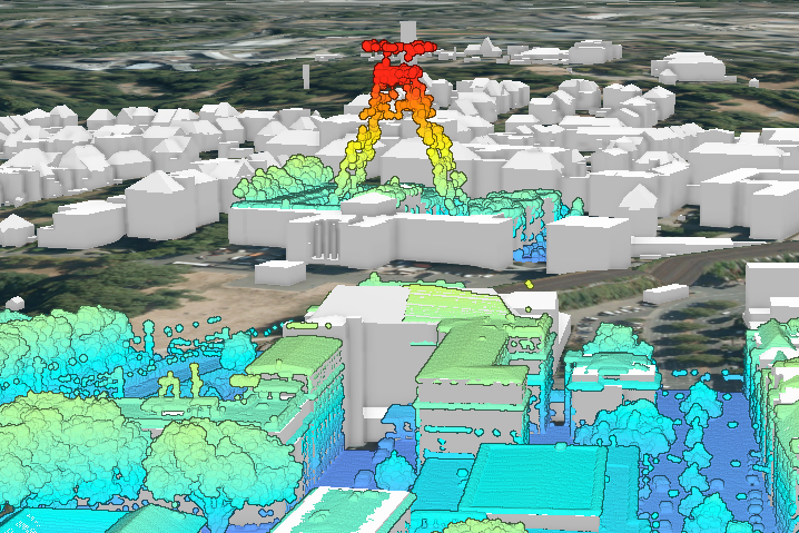
© FZN
This grant is funded by the German Space Agency at DLR e.V. with funds from the Federal Ministry for Economic Affairs and Climate Protection, which is supporting the project until 2023. BIMSAR is thus part of the funding program “Development and Use of Artificial Intelligence Methods in Satellite Earth Observation.” Close partners of the Research Center of Post-Mining in this project are EFTAS in Münster, Germany, the University Stuttgart as well as Vivawest Wohnen GmbH and the City Essem..
Project objectives
- Optimization of building and transport infrastructure monitoring through AI-based fusion and analysis of BIM and radar satellite remote sensing data
- Further development of combined monitoring methods
- Development of an in-depth understanding of ground movements and their impact on buildings and infrastructure
Contact

Prof. Dr. Tobias Rudolph
Technische Hochschule Georg Agricola University
Herner Street 45
44787 Bochum
Building 2, Room 101
Phone 0234 968 3682
Mail tobias.rudolph@thga.de

Prof. Dr. Peter Goerke-Mallet
Technische Hochschule Georg Agricola University
Herner Street 45
44787 Bochum
Building 2, room 206
Phone 0234 968 3289
Mail peter.goerke-mallet@thga.de