GIGASAR
New possibilities through the fusion of BIM and SAR data in the monitoring of infrastructure and urban spaces
GIGASAR is a project funded by the European Space Agency (ESA) to develop new methods for precise infrastructure monitoring. It combines high-resolution Synthetic Aperture Radar (SAR) data, Building Information Modeling (BIM) and additional geoinformation with AI-based methods to detect movements in the subsurface and in structures at an early stage and with a high degree of reliability. The aim is to develop market-ready services for European clients from industry and public administration.
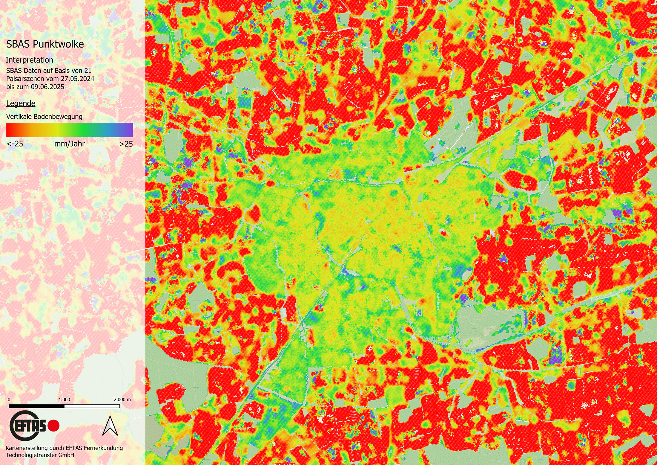
© EFTAS
In the GIGASAR project, the Research Center of Post-Mining (FZN) at the Technische Hochschule Georg Agricola in Bochum, together with EFTAS (Münster), is investigating how various high-resolution satellite radar datasets can be combined with digital building models and additional geodata into an integrated analysis approach. The focus is on how deformations and changes in infrastructure and urban spaces can be detected more precisely than with existing methods.
For this purpose, multi-frequency SAR data, including Sentinel-1, TerraSAR-X, and PALSAR-2, are combined with structural information on buildings and infrastructure as well as modern AI methods. This is intended to enable the reliable detection and assessment of both large-scale deformation processes and local changes affecting individual objects such as buildings, roads, bridges, or utility networks.
A key feature of the project is its consistent focus on practical application. GIGASAR is not only a research and development project but is explicitly aimed at creating commercially usable and scalable services for European users. The methods developed are being validated under real-world conditions in two test areas – a building complex in Bochum and an urban area in Ahlen.
In addition, a European stakeholder platform is being established to connect research, public administration, and industry. Workshops, training courses, and scientific publications are intended to help make the project results widely available and support their use in future European services.
Project objectives
- Development of an integrated approach for linking SAR data, BIM data, and additional geoinformation
- More precise detection of movements in the subsurface and in structures
- Derivation of both large-scale deformation processes and local changes affecting individual infrastructure objects
- Improvement of risk assessment for buildings, roads, bridges, and utility networks
- Use of modern AI methods for the analysis of complex infrastructure and environmental data
- Validation of the developed methods in real-world application environments
- Development of market-ready, scalable services for European clients from industry and public administration
- Promotion of knowledge transfer through the establishment of a European stakeholder platform
- Support for the transfer of the project results into future European services
Project duration
01.01.2026 – 31.12.2026
Approach
- Integration of different SAR frequencies, including Sentinel-1, TerraSAR-X, and PALSAR-2
- Integration of BIM data as well as additional structural and geospatial information into the analysis approach
- Use of modern AI methods for the evaluation and integration of the data
- Analysis of regional movement patterns and their linkage with object-specific indicators
- Investigation of two test areas: a building cluster in Bochum and an urban area in Ahlen
- Testing and refinement of the methods under different structural and geological conditions
- Establishment of a European platform for exchange between research, public administration, and industry
- Implementation of workshops and training sessions to communicate the project results
- Publication of scientific results to enable the broad use of the approaches developed
Project funding
Cooperation
Contact
Prof. Dr. Tobias Rudolph
Technische Hochschule Georg Agricola University
Herner Street 45
44787 Bochum
Building 2, Room 101
Phone 0234 968 3682
Mail tobias.rudolph@thga.de
Dr.-Ing. Benjamin Haske
Technische Hochschule Georg Agricola University
Herner Street 45
44787 Bochum
Building 2, Room 102
Phone 0234 968 3667
Mail benjamin.haske@thga.de
Vinicius Inojosa, M.Sc.
Technische Hochschule Georg Agricola University
Herner Street 45
44787 Bochum
Building 2, room 106
Phone 0234 968 3286
Mail vinicius.inojosa@thga.de

Prof. Dr.-Ing. Peter Goerke-Mallet
Technische Hochschule Georg Agricola University
Herner Street 45
44787 Bochum
Building 2, room 206
Phone 0234 968 3289
Mail peter.goerke-mallet@thga.de