The European Parliament has passed the first EU-wide methane regulation, which will come into force in June 2024. The aim is to reduce methane emissions in the energy sector.
Methan ist ein Treibhausgas und gilt nach Kohlendioxid als zweitgrößter Verursacher des Klimawandels. Es ist für etwa 30% des weltweiten Temperaturanstiegs verantwortlich. Die neue Verordnung legt verbindliche Ziele für eine Reduktion der Methanemissionen. Zu den Maßnahmen gehört, dass Betreiber verpflichtet werden, regelmäßig Rechenschaft über die Methanemissionen ihrer Quellen abzulegen. Unternehmen im Öl-, Gas- und Kohlesektor sind verpflichtet, ein Inventar stillgelegter, inaktiver, verschlossener und aufgegebener Anlagen zu erstellen, ihre Emissionen zu überwachen und einen Plan zur schnellstmöglichen Verringerung der Emissionen aufzustellen. Es gelten außerdem strengere Verpflichtungen zur Erkennung und Reparatur von Methanlecks. Darüber hinaus werden ab 2027 auch strengere Anforderungen für importiertes Öl, Gas und Kohle gelten.
The FZN specializes in revealing hidden underground processes by evaluating and merging different geodata. Whether public data, remote sensing methods or on-site analyses - the FZN can support the measurement and monitoring of methane emissions with technical expertise and advanced technology.
This includes tasks in four different areas:
Methane emissions at boreholes
- Developing an understanding of the process
- Compilation of publicly accessible data and integration
- Setting up an inventory
- Localization of boreholes through evaluation of satellite images and their documentation
- Evaluation of historical sources and old maps
- Configuration of 3D models
- Development of methods for quantifying methane emissions
- Method for distinguishing the gas origin (isotope analysis)
- Risk assessment when creating routine inspection plans
Methane emissions at the source and at site level
- Developing an understanding of the process
- Compilation of publicly accessible data and integration
- Setting up an inventory
- Configuration of 3D models
- Direct measurements at the source
- Developing monitoring systems
- Documentation and analysis of any deviations
- Additional quantifications at the source or measurements at site level to analyze possible reasons for any deviations
- Method for distinguishing the gas origin (isotope analysis)
- Numerical adjustments to the quantifications at the source or the measurements at site level
Methane emissions in decommissioned underground coal mines
- Compilation of publicly accessible data and integration
- Setting up an inventory
- Localization through evaluation of satellite images and their documentation
- Evaluation of historical sources and old maps
- Development of 3D models
- Developing monitoring systems
- Method for distinguishing the gas origin (isotope analysis)
- Concepts and solutions for the utilization of methane
- Appraisal
Methane emissions in active coal mines above ground
- Developing an understanding of the process
- Compilation of publicly accessible data and integration
- Setting up an inventory
- Configuration of 3D models
- Direct measurements at the source
- Method for distinguishing the gas origin (isotope analysis)
- Development of methods for determining emission factors from mining processes and post-mining activities
- Appraisal
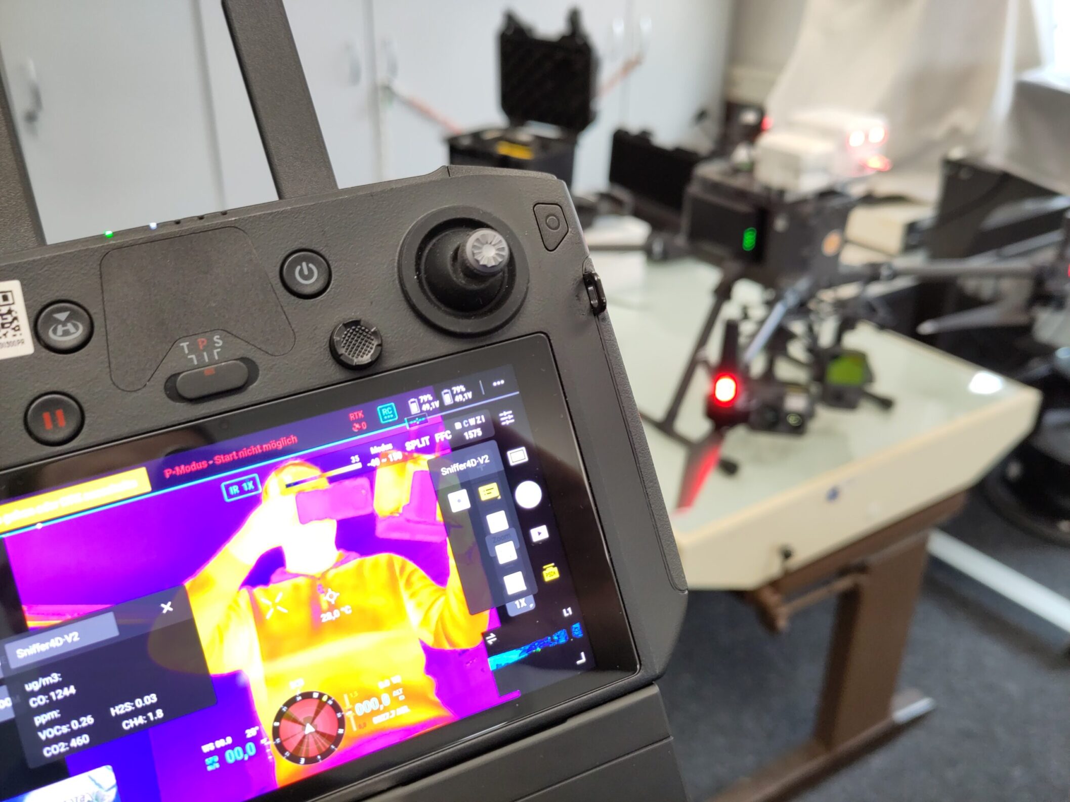
With the 4D gas sniffer drone including a laser scanner and high-resolution optical camera, gas emissions can be measured in real time and accurate to the coordinates. © THGA / Haske
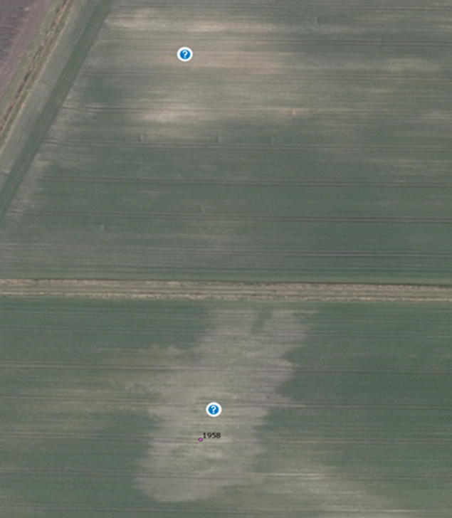
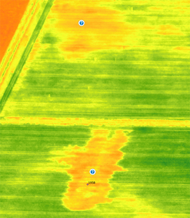
The multispectral image clearly shows a change in the vegetation. This can be an indicator of gas escaping over a large area. © THGA
Contact

Prof. Dr. Christian Melchers
Technische Hochschule Georg Agricola University
Herner Street 45
44787 Bochum
Building 2, room 104b
Phone 0234 968 3280
Mail christian.melchers@thga.de
Prof. Dr. Tobias Rudolph
Technische Hochschule Georg Agricola University
Herner Street 45
44787 Bochum
Building 2, Room 101
Phone 0234 968 3682
Mail tobias.rudolph@thga.de