BIMSAR 2
Large-Scale Urban and Infrastructure Monitoring with Artificial Intelligence in regions of transition
How can urban ground movements and infrastructures be analyzed and displayed? Experts from the Research Center of Post-Mining and EFTAS are developing a solution for this in the project BIMSAR 2. The full project title is “AI-based fusion and analysis of BIM and SAR data for improved building and infrastructure monitoring - Phase 2: Extension for large-scale infrastructure monitoring”. In the earlier project, BIMSAR, the researchers already succeeded in combining data from building information modeling (BIM) and remote monitoring of the earth's surface in the form of radar interferometry (InSAR). The amount of geospatial information generated in the process is processed into a hybrid model using artificial intelligence (AI).
In BIMSAR 2, these findings will be fused with data from radar satellite remote-sensing (Sentinel-1, TerraSAR-X, ALOS-PALSAR) to identify ground movements and learn more about their influencing factors (e.g. soil moisture). This will allow the researchers to create a holistic model that reveals the environmental interaction between ground movements, subsurface structures, including mining infrastructure, geology, hydrogeology and climate conditions, and shows whether subsurface movements are due to mining or climate-related causes.
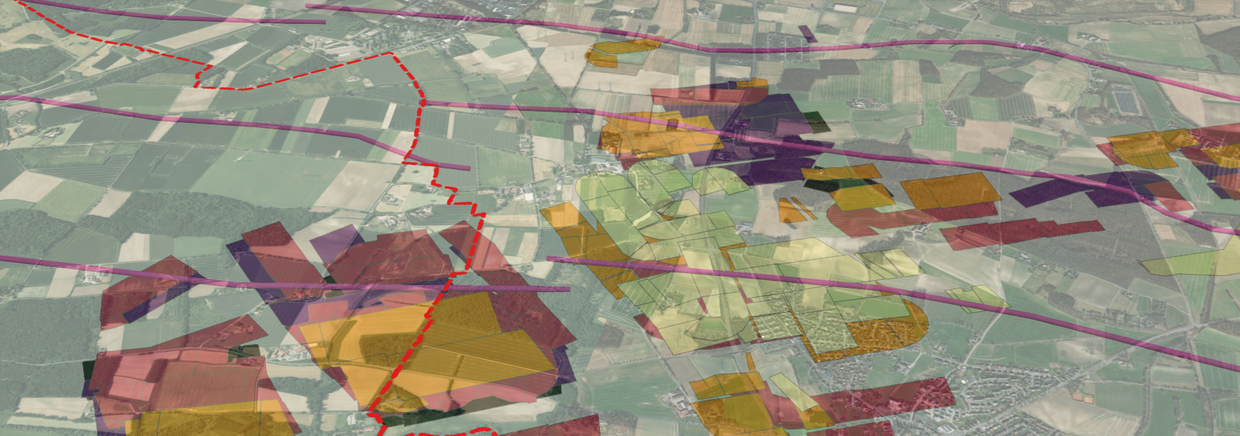
3D view of a former mine in Ahlen, including geoinformation on carbon layers (purple lines), administrative boundaries (red line) and mining areas, created with ArcGIS. © THGA / Koppe
Another aim is to create an online platform that can depict urban planning models including the subsurface. By merging this with data on ground movements, a 4D visualization of the movement dynamics of entire city districts will be possible for the first time.
The German Space Agency at DLR e.V. is backing the project for one year with funding from the Federal Ministry for Economic Affairs and Climate Protection.
Project objectives
- Large-scale urban infrastructure monitoring through AI-based fusion and analysis of BIM- and SAR data on ground movements
- Identification of damage-causing ground movement processes and development of a deeper understanding of thes interactions
- Visualization of the ground movement dynamics on an online platform
- Pilot run of the developed AI processes on the former Westfalen-Mine in the city of Ahlen, a region in transition
Contact
Prof. Dr. Tobias Rudolph
Technische Hochschule Georg Agricola University
Herner Street 45
44787 Bochum
Building 2, Room 101
Phone 0234 968 3682
Mail tobias.rudolph@thga.de